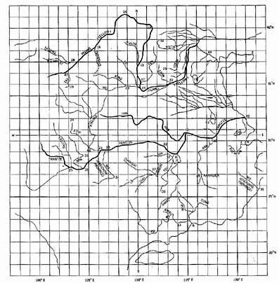
MAP OF THE TRACKS OF YU THE GREATThe Yu Chi Fu, or map of the Tracks of Yu the Great was carved in stone 1137. It is known to have been in use for an indefinite period before that. Like the portalanos of the West the real date of origin is unknown. A comparison of the river system shown on this map with that on a modern map of China shows a remarkable accuracy (see Figs. 77 and 78). This map was evidently drawn with excellent information as to longitudes, such as we find on the portalanos, but do not find on the classical maps of Greece and Rome, and which was certainly not typical of the cartography of medieval China or Japan.
The Yu Chi Fu with oblong grid constructed empirically from the geography. As a further test of the grid I had drawn for the map, I listed separately all the northernmost and southernmost places identified on the map and averaged their errors in latitude. I also listed all the easternmost and westernmost places and and averaged their errors in longitude (Tables 10b and 10c). The average error of latitude on the north was less than one-half of one degree (or 30 miles!), and the average error on the south balanced out to zero (with four localities 1� too far south and four 1.2� too far north). So far as longitude was concerned, the error both on the east and on the west balanced out to zero. There was no indication, therefore that the grid constructed for the map was seriously in error. From Maps of the Ancient Sea Kings by Charles H. Hapgood |