antarctica
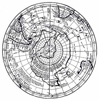
The Philippe Buache map of Antarctica, made in Paris in 1737, a century before Antarctica was discovered. Evidently copied frm maps surviving from ancient times, it shows Antarctica as two separate land masses, a fact no established until the Geophysical Year of 1958 through ice soundings, but evidently known to navigators of prehistory, who may have visited Antarctica before it was covered by ice. From
Mysteries of Forgotten Worlds by Charles Berlitz
|