THE ORONTEUS FINAEUS MAP OF ANTARCTICA
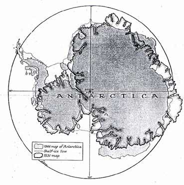
The Oronteus Finaeus Map of Antarctica redrawn on the modern equidistant azimuthal polar projection, compared with the modern map of Antarctica on the same projection (Christian Science Monitor) A comparison of the Oronteus Finaeus Map with the map of the subglacial land surfaces of Antarctica produced by survey teams or various nations during the International Geophysical Year (1958) seems to explain some of the apparent short-comings of the Oronteus Finaeus Map, and at the same time throws some light on the question of the probable extent of glacial conditions when the original maps were drawn. From Maps of the Ancient Sea Kings by Charles Hapgood
Maps of the Ancient Sea Kings Index Maps of the Ancient Sea Kings by Charles Hapgood |